Abstract
Cross-view geo-registration is the task of aligning a query image to a geodetically accurate reference (e.g., satellite image), so that each query pixel maps to a real-world GPS coordinate. Most existing work addresses the related problem of cross-view geo-localization, where the goal is typically to estimate the camera center using retrieval, classification, matching, or regression. Because these approaches do not provide dense supervision, they are poorly suited for learning and evaluating pixel- wise alignment. We introduce SkyReg, a geometry-aware geo-registration model that estimates the transformation between the query and reference images by explicitly modeling the 3D scene geometry. Applying this transformation to warp the query into the reference frame yields pixel-wise geo-localization, without relying on 2D point matches, and remains robust to occlusions and large viewpoint changes. To enable training and standardized evaluation, we release (i) SkyReg-130k, a large-scale dataset of drone–satellite images annotated with per-pixel GPS co-ordinates, depth maps, and camera parameters derived from LiDAR and structure-from-motion, and (ii) SkyReg-Bench, a held-out benchmark of unseen Urban and Suburban scenes with the same dense annotations. SkyReg achieves state-of-the-art performance against strong retrieval and homography baselines, demonstrating the value of geometry-aware models and dense geodetic benchmarks for cross-view geo-registration.
SkyReg130k/SkyReg-Bench Dataset
We introduce SkyReg-130k and SkyReg-Bench, a dataset for training and benchmarking drone–satellite geo-registration. SkyReg spans diverse locations, scene types, and camera configurations, and provides dense supervision, including per-pixel GPS coordinates, metric depth, and full 6-DoF camera poses, which enable evaluation beyond image-level geo-localization. Each sample contains a geodetically accurate reference image with a per-pixel latitude–longitude array. We support two reference modalities: (i) orthorectified satellite tiles paired with a digital elevation map, and (ii) perspective-projection satellite views paired with metric depth and camera parameters defined in an ECEF world frame. The query is always a perspective-projection drone image with metric depth and camera parameters also in ECEF.
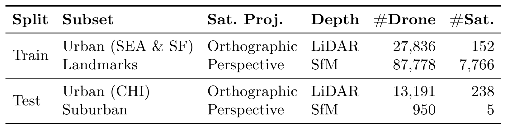
Table shows number of drone queries and satellite references for each split and subset, along with the satellite projection type and the depth source used to derive dense geodetic supervision (LiDAR for Urban; SfM for Landmarks/Suburban).
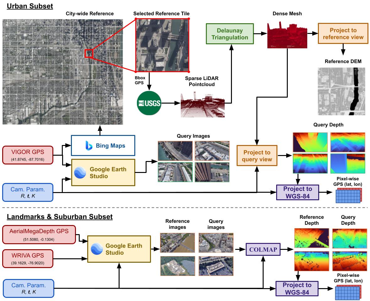
We use VIGOR GPS coordinates from three cities (San Francisco, Seattle, Chicago) to download orthorectified Bing Maps tiles and render perspective drone views in Google Earth Studio. LiDAR point clouds from USGS are densified via Delaunay triangulation and projected into the known cameras to produce DEMs, depth maps, and per-pixel latitude–longitude labels through projection to the WGS-84 ellipsoid. Landmark drone images come from AerialMegaDepth, while landmark references and all Suburban imagery are rendered in Google Earth Studio. Depth is obtained with a structure-from-motion pipeline using fixed camera parameters, and pixel-wise GPS is computed using the same 3D-to-WGS-84 projection as in Urban.
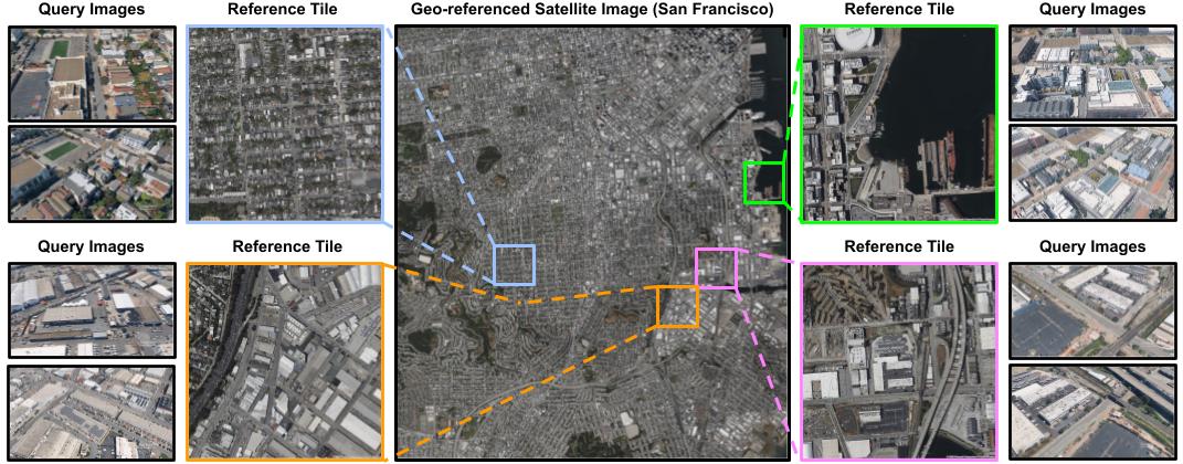
The figure shows a few examples from SkyReg-130k (Urban). The center panel shows a large orthorectified satellite image of San Francisco. We create reference satellite images from local reference tiles. The left/right panels show example drone queries associated with each reference tile.
Method Overview
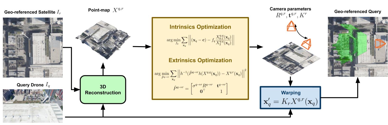
SkyReg operates in two stages. First, a feed-forward 3D reconstruction backbone predicts dense point maps, camera intrinsics, and the relative pose between the query and reference views. Second, we compose these predictions into a query-to-reference warping function that lifts query pixels into 3D and reprojects them onto the reference image plane. We then obtain a GPS coordinate for each query pixel by interpolating the reference’s geodetic map at the warped locations.
Results
Tables show that our method consistently outperforms retrieval-based and homography-based baselines by a large margin in both the pixel-wise and median GPS geodetic error and recall. Relative to the strongest competing baseline (RoMa), we reduce the pixel-wise geodetic error by 88.18 m and 90.76 m in the Urban and Suburban splits, respectively. On the median GPS evaluation we observe a similar trend, reporting 68.30 m and 76.33 m lower error than RoMa. Recall exhibits the same trend: SkyReg registers a substantially larger fraction of images across all distance thresholds, indicating robust behavior rather than gains concentrated on a small subset of easy examples.
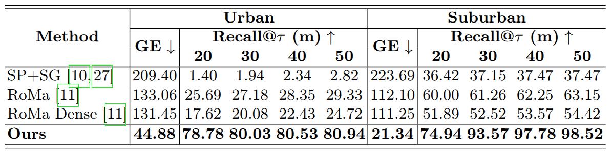
Table shows pixel-wise georegistration performance on the Urban and Suburban benchmarks. We report the mean geodetic error (GE) in meters, and the recall of images registered correctly under τ as a percentage.
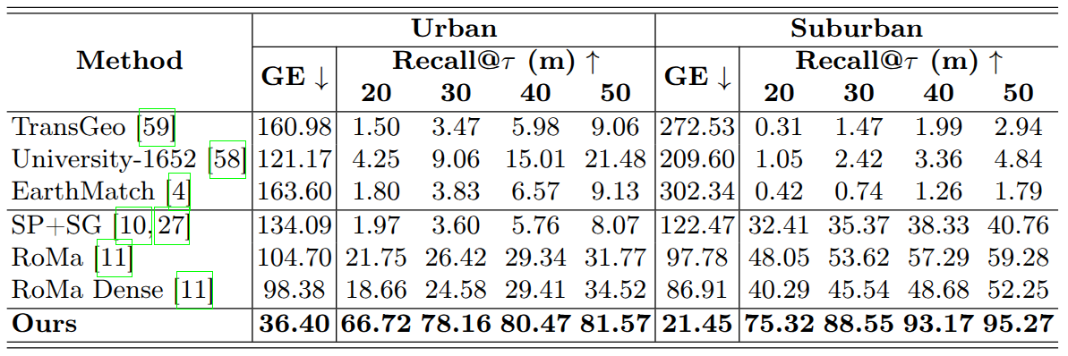
Table shows center-pixel geo-localization performance on Urban and Suburban benchmarks. We report the mean geodetic error (GE) in meters, and the recall of images geolocated correctly under τ as a percentage
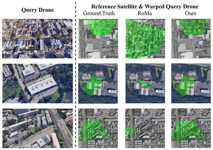
For each example, we warp the query drone image into the geodetically accurate satellite reference frame and visualize the overlay in green. From left to right: (1) query drone image, (2) ground-truth warp obtained using the ground-truth depth map and camera parameters, (3) RoMa result (homography-based), and (4) SkyReg (ours). RoMa often fails under large cross-view viewpoint/ scale changes; even when successful, a single planar homography cannot model parallax, leading to stretching or shearing of elevated structures. In contrast, SkyReg’s 3D-aware warping more closely matches the ground-truth alignment and naturally respects occlusions, producing sharper, geometrically consistent overlays.